 Balai Chandra Das
 Aznarul Islam
 Shrabani Das1
- 1Department of Geography, Krishnagar Government College, Krishnagar, West Bengal, India
- 2Department of Geography, Aliah University, Kolkata, West Bengal, India
River-road crossings are one of the basic infrastructures for rolling the wheels of development of the modern world facilitating connectivity and overcoming geographical obstacles. Their impacts on the hydro-geomorphology of the riverine landscape and the lotic habitat is a long concerning issue amongst scientists, planners and stakeholders. The construction of a new highway bridge over the Jalangi River commenced a few years ago, experiencing occasional halts and progressing at a notably sluggish pace. However, in 2022, the construction gained momentum and was completed in 2023. The study aims to evaluate the influence of the bridge and its construction procedures on the river’s channel morphology and turbidity. We gathered data on various structural aspects of the recently built highway bridge at Krishnagar spanning the Jalangi River, a dying distributary of the Padma River. This included assessments of channel geomorphology and information to water turbidity. To assess the impact of road crossing on channel geomorphology we applied tools of w/d ratio, channel efficiency and channel asymmetry (A*). At-a-station channel geomorphology of the river was drastically impacted by the structure of the bridge and its construction processes. As the river is a dying one, the impulse of road crossing felt to the downstream insignificant. The impact of road-river crossing on water turbidity appears significant at the construction site. Non-clearance of debris and soil from river beds and banks obstructed animal movement along the river banks. In like environments where robust data forms the foundation, it is recommended to pursue additional research to identify a mitigation strategy for the way forward.
Introduction
Despite several dissimilarities, road networks and river systems have several commonalities. Both are long and linear transporting features of the landscape (Jackson, 2003). Connectivity is key to the continued functioning of both systems. Road-stream crossings are inevitable in the development process of the present world. And intervention with linear stream ecology and morphology has become a fundamental issue in fluvial-geomorphic and aquatic-ecological investigations (Biswas et al., 2021). The impact of road-crossing over in-channel and extra-channel geomorphology has been studied by several scholars (Jones et al., 2000; Jackson, 2003; Bouska et al., 2010; Blanton and Marcus, 2009; Thomaz et al., 2014; Thomaz and Peretto, 2016; Roy and Sahu, 2016; Das, 2019). Road networks affect fluvial forms and processes in two different directions-laterally and longitudinally. Roads running parallel to the river disconnect channels from their floodplains and which alters the natural fluxes of materials (sediment, nutrients, flood water), energy and creates obstructions to the roaming of animals (Junk et al., 1989; Shuangcheng et al., 2005; James and Marcus, 2006; Liu et al., 2014). On the other hand, in-channel geomorphology is mainly affected by the stream-road-crossings and interrupts longitudinal connectivity which is related to the upstream-downstream linkage and transfer of matter and energy (Brookes, 1988; Erskine, 1990; Cong et al., 2014; Roy and Sahu, 2016). Improperly designed river-crossing structures may cause alternation of stream geomorphology and create environmental harm to the aquatic habitat (Resh, 2005; Wheeler et al., 2005; Merril and Gregory, 2007; Bouska et al., 2010). Road-stream crossings affect behavioural ecology, especially the movement of nocturnal animals (Murray and St. Clair, 2015), aquatic animals and fish.
Therefore, the objectives of any road-stream crossing should include the minimum interruption with the natural fluvial forms and processes along with bridging opposite banks of the rivers. Rivers themselves, through their magnitude of channel geometry (channel width and depth) and processes (erosion, transportation and deposition of sediment and working and reworking within and outside the channel) can influence the structural design of road crossings (Das and Bhattacharya, 2020; Das and Das, 2020). In most cases of engineering constructions within or across the river channel, planners’ prime concern is the longevity of the structure (Li et al., 2020). The concern related to the health of rivers remains neglected especially in developing countries (Özmen et al., 2019). So, if the river is of very large magnitude in terms of its cross-sectional dimension and hydraulics, then the structures of the bridge and its construction processes are designed in such a way as to minimise interference with the channel hydraulics to reduce the failure risk of the structure (Larrarte et al., 2020). But if the river is a decaying one with feeble flow, un-proportionately wide platforms at pier bases are erected within the channel. Sometimes, construction methods also exert significant impacts not only on the channel morphology but also on hydraulics (Das, 2019).
The impact of road-stream crossings on river hydrogeomorphology in the moribund deltaic Bengal are reported by Sarkar et al. (2020; 2021), and Biswas et al. (2021). The construction of bridge piers on raised broad dias on the river bed and its impact on cross-sectional channel morphology (channel asymmetry, width/depth ratio), flow diversion, and bank erosion of Jalangi River was examined by Das (2019). The change in channel cross-sectional morphology along with localized impact on flow hydraulics of the Churni River was estimated by Sarkar et al. (2020). Interruption to the flow of the Ichhamati River and consequent in-bed siltation due to the presence of bridge piers have been reported by Biswas et al. (2021).
Jalangi is a moribund river of deltaic Bengal (Figures 1A–D). It is a distributary of the river Padma (Ganga) and a tributary of the river Bhagirathi (Das, 2015b; Das, 2015c). Till the 19th century, the river would take off its supply from the river Padma at Jalangi and was navigable throughout the year for boats of considerably large size. But now the off-take of the river is completely closed and no supply comes through its own off-take (Table 1). Since 1874, following the opening of the new entrance of the Bhairab River, the Jalangi River began receiving its water supply through Bhairab (Reaks, 1919, P. 54-55). However, over time, the Bhairab River also experienced a decline, with its flow nearly ceasing after 2020. The discharge of the Jalangi River (Table 1) from 1890 to 2009 shows significant fluctuations. This variability could be due to a combination of actual discharge fluctuations and differences in measurement methods used by various authorities. However, the sharp decline observed from 1987 onwards is particularly noteworthy.
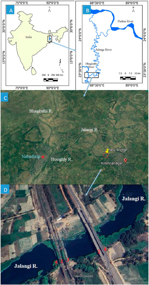
Figure 1. Location of the study. (A) The Bhagirathi River within India. (B) Bhagirathi-Jalangi confluence and their lower reaches. (C) Google Earth Pro image showing location of the New Bridge on the river Jalangi. (D) Google Earth Pro image showing detailed location of existing four bridges and the 5th Bridge under construction on the river Jalangi.

Table 1. Decline in the discharge of the River Jalangi.
The river maintains its course, though during two to 3 weeks of monsoon months only, being fed by the River Bhairab and some spills. River Bhairab is a distributary of the river Padma and at the same time a tributary to the river Jalangi. Bhairab takes off from the river Padma at Ankhriganj, about 5 km upstream from Hursi and falls into the river Jalangi at Char Moktarpur in C. D. Block Karimpur-II (Das and Bhattacharya, 2020). A dying river like Jalangi is very vulnerable to any interference within its bed and needs careful consideration for the construction of a bridge over it. At present, there are nine (including incomplete bridges) bridges over the river (Table 2). Out of these nine, four bridges are at Krishnagar (the fifth one, i.e., the third railway bridge, 20 m downstream to the first railway bridge has been under construction since 2023), the headquarters of the district of Nadia. At Krishnagar, 15.5 km upstream from the Bhagirathi-Jalangi confluence, NH-34 and Sealdah-Lalgola railway line crosses the river Jalangi. A New Railway Bridge (NRB) was constructed there in 2012 to host the 2nd track of the railway line. Another bridge on NH-12 (formerly NH-34) at Krishnagar was completed in 2023. On 2nd April 2023, the bridge became accessible for traffic. This is the 4th bridge at the site within a span of 200 m. The pier span, the dais at the base of the piers, and the construction procedures of this 4th bridge have left a notable impact on the channel morphology and riverine ecosystem and are the key concern of the present study. The present study is designed to seek what imprints are left by this bridge on the channel morphology at a station. How extensively has the channel morphology altered? Objectives of this present study are therefore, i) to the dimensions of piers and dias at the bases within the river bed, ii) to estimate the magnitude of alteration of the cross-sectional form of the channel by the processes of bridge construction, and iii) to evaluate the extent of anthropogenic impacts of bridge construction on at-a-station and downstream hydrogeomorphology and at-a-station turbidity of the river.

Table 2. Features of five bridges on the river Jalangi at Krishnagar.
The research delves into a crucial yet underexplored realm: the impact of bridge construction on the channel morphology of a dying river like Jalangi. With a meticulous focus on the New Highway Bridge traversing the river, at Krishnagar, it scrutinizes the ramifications of such infrastructural interventions. Notably, the study addresses the pressing concerns surrounding channel morphology alterations and the resultant effects of construction processes on water turbidity. This research pioneers an essential inquiry into mitigating adverse consequences and fostering sustainable development practices for vulnerable river ecosystems.
Study Area
Jalangi, translating to “body made of water,” serves as a distributary of the Ganga River in eastern India (Figures 1A–C). Originating from the northernmost point of Nadia district, West Bengal, India, at coordinates 24° 05′ 26˝ N and 88° 4′ 53″ E, it meanders along a sinuous path with a sinuosity of 2.67, covering a distance of 233 km before merging with the Bhagirathi River at Swarupganj (23° 29′23″ N, 88° 28′ 57″ E). Approximately 96 km of its course runs along the Nadia and Murshidabad district borders, while the remaining 137 km traverse through the Nadia district. The stretch from its origin to the confluence with the Bhairab River at Char Moktarpur village in Nadia district spans 51 km and is characterized as a stagnant channel. Beyond this point, Jalangi carries water, although with restricted flow from July to November (refer to Figures 1A–D). During the monsoon season, for a week or two, the Bhairab River maintains a flow of 182 km downstream to Char Moktarpur village. But last two or three years, the offtake of the Bhairab has been closed and water from the Ganga has not entered the river. Almost the entire length of the river has been covered with hyacinth and different kinds of submerged and floating weeds. We apprehend that, like, an upper reach of 51 km, the total course of the river will cease to exist within a few decades.
With a catchment area of 4,300 km2, the river basin features a gently sloping recent alluvium-filled plain (Majumder, 1978) dotted with swamps, paleo-channels, oxbow lakes, and meander scars (Dasgupta, 1997). These features contribute water to Jalangi through various tributaries such as the Sialmari River, Bhairab River, Suti Nala, and Kalma khal. Additionally, overflow channels like Bhairab khal, Krishna-Rai Khal, Saraswati khal, and Anjana River help manage excess water during peak flow periods. The Sealdah-Lalgola railway track and the National Highway 12 (NH-12, formarly NH-34) run across the river at Krishnagar, the district headquarter of Nadia. There are two railway bridges and two highway bridges at the site. The first railway bridge was constructed in 1905 during British rule. The second railway bridge came into function in 2012. The first highway bridge was constructed at 155 m upstream of the old railway bridge and the second highway bridge, the focal theme of the study of this paper, came into operation on 2nd April 2023 (Table 2).
Methodology
Generation of Data on Bridge Structures and Construction Methods
Structures within the river can alter channel morphology, the most sensitive indicator to the construction of piers and associated channel scouring and bed deposition. To address this, precise measurements were taken of the bridge’s piers and platforms at their bases. Utilizing tools like auto level and measuring tape, we determined the diameter of the piers and the length, width, and thickness of the platforms. This detailed assessment provides valuable data for understanding how these elements influence the river’s cross-sectional morphological dynamics and aids in informed decision-making for effective river system management.
Cross-Channel Morphometry
Using dumpy level, and accessories we measured width (w), average depth (
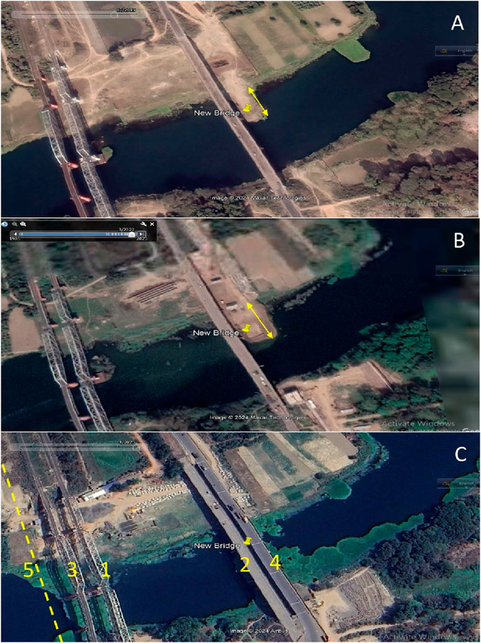
Figure 2. Google Earth Pro images showing different phases of bridge constructions and interference with the channel morphology. (A) Image of December 2015 showing soil filling within the channel from the right bank. (B) Image of March 2022 showing soil filling within the channel from the right bank and diases at the base of the pier are constructed. (C) Image of April 2023 completion of the bridge. Numbers from 1 to 5 written in yellow represents the sequences of bridges on the river (2 and 4 are highway bridges and 1, 3 and 5 are railway bridges).
Channel Asymmetry (A*) is a very ubiquitous property of an active alluvial meandering channel. We wanted to know to what extent or not this property of the channel cross-section has been impacted by the construction of the bridge. Therefore, the formula as proposed by Knighton (1981) was applied to detect temporal variation in channel asymmetry (Equation 1).
Where
Any perturbation in the channel shape may influence the efficiency of the channel for carrying its sediment and water. To what extent or not the efficiency of the channel (Das, 2015a) responded to the impulse of bridge construction was estimated using (Equation 2).
Where w is the channel width,
Water Turbidity
Turbidity at the Construction site, 200 m and 5 km downstream and 200 m and 2.5 km upstream were measured using Secchi Disk. The depth of the Secchi Disk was used to find out the Turbidity in Formazin Nephelometric Units (FNU) (Rasmussen et al., 2009).
where
Result and Discussion
There are a total of nine road crossings over the river Jalangi-three railway bridges and six roadway bridges. Out of six roadway bridges, two roadway bridges (one at Karimpur-Bakshipur and another at Fazilnagar-Aamtala) are left incomplete and abandoned. Rest four functioning roadway bridges are–the first one at Radhanagar-Patikabari, the second one Dwijendralal Setu at Palashipara-Tehatta road, and the third one Dwijendra Setu at Krishnagar. The fourth one, subject of present studyis also at Krishnagar which is located ̴5 m upstream of the Dwijendra Setu and came into function on 2nd April 2023. Information related to piers is summarized below (Table 3). Henceforth, this new highway bridge, the pivot point of this paper, will be called as ‘New Bridge’ in this present study.

Table 3. Dimensions of old and New Highway Bridges.
Immediate Impacts of Bridge Construction Processes
The construction processes of the “New Bridge” created a great impact on channel morphology within a short period of 5 years (2017-2023). For bridge construction, an earthen basement of 34 m wide was made and the river bed was filled with soil first on the right bank side and then on the left bank side (Table 4; Figure 3).
Table 4. Volume of soil fill and changes in channel form during construction processes of the bridge.
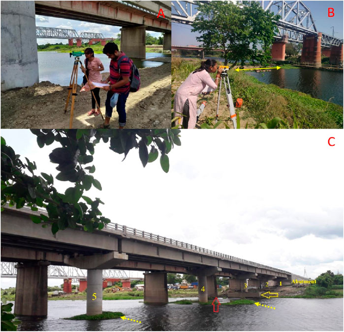
Figure 3. (A) The volume of soil fill for facilitating construction processes is being estimated by Shrabani Das (co-author) and her classmate. (B) The cross-sectional morphology of the channel downstream of the 3rd railway bridge is being measured. (C) A wide yellow arrow points towards the right bank, showing a dias well above the water level of the channel as of 20.07.2024. Notably, the earth-filling from the bank to the dias has partially closed the channel. The red wide arrow points to the pier without a dias of the old bridge and the flow surrounding the pier. Dotted yellow arrows indicate the hyacinths stuck to the dias at the base of the piers of the new bridge.
Due to the soil filling aimed at facilitating construction, over half of the channel width was alternately closed on both sides, resulting in a significant change in the cross-sectional profile of the river (Figure 4A). In 2017, the construction of the New Highway Bridge began involving the putting of soil for the approach road to the pier site. At that time, the cross-sectional area of the channel was measured at 1,139.13
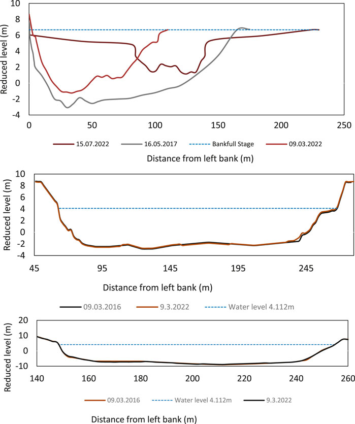
Figure 4. Temporal Changes in cross-sectional profiles of the river Jalangi. (A) Soil fill for the construction process and changes in the cross-sectional form of the channel at the construction site. (B) Temporal Changes in cross-sectional profiles 100 m upstream of the New bridge of the river Jalangi. Riverbed levels on two different dates: March 9, 2016 (in black) and March 9, 2022 (in brown). (C) Temporal Changes in cross-sectional profiles 400 m downstream of the New bridge of the river Jalangi. The figure compares the riverbed levels on two different dates: March 9, 2016 (in brown) and March 9, 2022 (in black).
River engineering has led to significant changes in Italian rivers, with Surian and Rinaldi (2003) observing channel widths decreasing by up to 50% or more. Although narrower channels are generally associated with increased scouring (Roy and Sahu, 2017), this was not the case for the Jalangi River. This absence or negligible scouring is attributed to the river’s stagnant nature, which has diminished its erosive capacity.
For the construction of the New Bridge, a total of 23,653
Upstream Impact of Road Crossing on Channel Morphology
The Figure 4B shows the cross-sectional profile of the river at a location 100 m upstream from the bridge site. It compares the riverbed levels on two different dates: March 9, 2016 (in black) and March 9, 2022 (in brown). The water level is marked at 4.112 m with a blue dashed line (9.3.2022). The cross-sectional profiles from both dates are very similar, indicating minimal change in the riverbed’s shape over the 6 years. A* calculated for both the dates are −0.037 and −0.033 respectively. These suggest that the bridge construction might not have significantly altered the overall form of the river cross-section at this location.
The minor deviations between the two profiles could be attributed to natural sedimentation and erosion processes. The consistent profile indicates that the river channel upstream of the bridge has remained stable. The construction of the bridge does not appear to have significantly altered the upstream cross-sectional profile of the river.
Downstream Impact of Road Crossing on Channel Morphology
The inauguration of the second railway bridge in 2012 had a profound impact on the channel morphology at different stations, causing significant disruption to the river’s flow. The mid-channel dais, situated at the base of a pier, played a pivotal role in altering the hydraulics of the river. During the floods of that year, the mid-channel dais compelled the flow to divert along the left bank, leading to substantial failure of the left bank approximately 50 m downstream of the bridge (Das, 2019). The alteration in the river’s cross-sectional form and flow pattern was notable because, in 2012, the Jalangi River received water from the Padma River for several weeks. However, as observed by the authors of this paper, by 2022, this duration had decreased to just three to four days, and by 2023, it was only 2 days. As a result, the river did not have enough force to create a significant downstream channel signature in response to the interference caused by the bridge’s construction.
A cross-sectional measurement taken 400 m downstream of the bridge revealed no significant difference between the pre-and post-bridge forms of the channel (Figure 4C). It compares the riverbed levels on two different dates: March 9, 2016 (in brown) and March 9, 2022 (in black). The water level is marked at 4.112 m with a blue dashed line (9.3.2022). The cross-sectional profiles from both dates are very similar, indicating the minimal change in the riverbed’s shape over the 6 years. A* calculated for both the dates are −0.0255 and −0.0257 respectively. Lagasse et al. (2012) and Das (2019) proposed that lateral and vertical scouring lead to alterations in channel morphology downstream of a bridge site. However, since the Jalangi River is no longer connected to or fed by the Padma River, it lacks the necessary force to cause scouring to alter its channel form. As a result, the bridge’s construction hasn’t noticeably changed the river’s shape downstream.
Construction Processes and Water Turbidity
The turbidity of water is instantly and very highly controlled by the construction processes. At the construction site, it was recorded >250 NTU whereas, 200 m and 2.5 km upstream and 200 m and 5 km downstream, the result was 7.77 NTU, 0.72 NTU, and 0.55 NTU, 1.88 NTU respectively. The 7.77 NTU at Kadamtala Ghat (bathing place) may be the result of the processes of idol immersion. Fishermen experienced negligible catch at the construction site. Kuşku et al. (2018) attributed negligible catch to the disturbance caused by the construction processes, specifically the irritating sounds and vibrations. Fish tend to avoid the construction site due to these disturbances. Furthermore, the adverse impacts of construction processes on aquatic wellbeing go beyond just the disturbance. High turbidity levels, measured at greater than 250, and an increased presence of suspended solids can have detrimental effects on aquatic life. These conditions may lead to issues such as clogging fish gills and hindering the filter-feeding mechanisms of other aquatic creatures (Lowe et al., 2015; Rodrigues et al., 2023). Moreover, the elevated turbidity levels can impede visibility in the water. This complication makes it challenging for predators to effectively search for prey. It creates an ecological imbalance, affecting the natural predator-prey dynamics in the aquatic ecosystem in the short run with adaptation-induced evolution in the long run (Utne-Palm, 2002; Hansen & Dragoi, 2011; Ehlman et al., 2015). In the context of River Jalangi, few communities like crabs and fishes at higher trophic levels (e.g., Ompok pabo, Wallago attu, Eutropifchthys vacha, etc.) depending on the smaller fish species (e.g., Labeo bata, Puntius sarana, Amblypharyngodon mola, etc. Khan & Sarkar, 2017) and other aquatic micro-organisms (e.g., Algae, amoebas, euglena, plasmodium, slime moulds) face difficulty for catching their prey for the short spatial (∼15 km) and temporal scale (∼2 years). Thus, long-term species evolution is not the outcome for this stretch of the Jalangi River. DeVore et al. (1978) conducted a study that reported a significant adverse impact of red clay turbidity specifically on salmon reproduction (Lloyd, 1987). This finding highlights the broader consequences of turbidity on the reproductive processes of important aquatic species (Lloyd, 1987), underlining the ecological importance of addressing and mitigating these issues in construction sites near water bodies (Järvenpää et al., 2019).
Careful consideration for the construction of bridges over deteriorating rivers, with a focus on river health and the longevity of the bridge, are essential. Emphasis should be placed on several key considerations to ensure the success and sustainability of such projects. When planning bridge construction over deteriorating rivers, prioritizing river health is crucial. Assessing and addressing the ecological wellbeing of the river should be integral to the project design and execution. This involves considering the impact of construction activities on channel form (Sarkar et al., 2020), water quality, aquatic life, and overall river ecosystem health (Islam et al., 2023).
It is strongly recommended to ensure that the base of the bridge piers is not made on dias. The presence of dias at the base of piers can pose a serious obstacle within the channel (Das, 2019), affecting both the natural flow of the river and the movement of aquatic organisms (Wang et al., 2023). However, the third railway bridge (Figure 5), which has been under construction since 2023, is also designed to include a dias at the base of the piers.
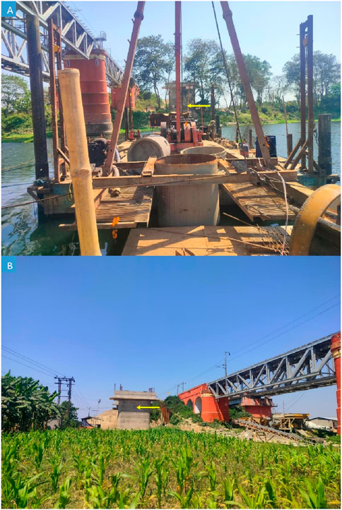
Figure 5. The third railway bridge (the fifth bridge at Krishnagar) downstream of the first railway bridge is under construction. (A) Towards the left bank. Arrow indicating piers. (B) Towards the right bank. Photo captured by Sayan Hazra on 30.08.2023.
Earth or soil placed in the river during construction to facilitate the building process should be diligently removed once construction is completed. Leaving construction debris in the river can have adverse effects on water flow (Das, 2019), sedimentation, and overall river health. Responsible disposal practices should be employed to minimize environmental impact. The negligence of removing construction debris from the Jalangi River by the construction agency was brought to the attention of the National Highway Authority of India (NHAI) by “Save Jalangi,” and other activist groups. As a result of this initiative, in June 2024, KCC BildconPvt. Limited removed earth and concrete slabs from the riverbed and banks (Figure 6).
Figure 6. Post-construction removal of soil and debris from the river bed and banks by NHAI. (Curtsy: The Telegraph Online, 02.07.2024).
After the bridge construction, it is imperative to keep animal corridors on both sides of the river clear. Bridges can sometimes disrupt natural migration patterns and habitats for wildlife (Xia et al., 2007; Lee et al., 2012; Okita-Ouma et al., 2021). Fox (Vulpes bengalensis), Jackles, Mongoose, Monitor lizards, and Civets are some animals that live and move along the Jalangi river banks. Ensuring unobstructed pathways for these animals helps maintain ecological balance and supports the biodiversity of the surrounding area. Since the inauguration of the ‘New bridge’, the animal corridor has been obstructed by the dumping of concrete slabs and soil. After repeated petitions by various environmental activist groups, the soil and debris were finally cleared from the riverbed and the area around the abutments in June 2024 (Figure 6). This obstruction is likely a short-term issue. However, it could have had long-term impacts, as seen with the railway bridge. These potential long-term impacts were avoided because environmental activists persistently pressured the authorities.
A holistic approach that integrates river health, pier base integrity, responsible debris removal, consideration for animal corridors, and preservation of the original channel form is essential for sustainable and environmentally conscious bridge construction over deteriorating rivers.
Conclusion
Emphasizing the New Highway Bridge in Krishnagar, the study investigates the impact of bridge construction on channel morphology and turbidity of the Jalangi River. This research pioneers efforts to address concerns and promote sustainable development practices for vulnerable decaying rivers. River Jalangi is a dying distributary of the river Padma, literally detached from the feeder channel except for very few days a year. Therefore, anthropogenic interference with the river channel keeps substantial imprints on the channel shape and cannot absorb the stimulus by active reshaping processes. The New Bridge on NH -12 and its construction processes have changed the at-a-station channel geomorphology of the river Jalangi. Width/depth ratio, channel asymmetry, hydraulic radius and channel efficiency changed significantly within a short period of construction. It is concluded that the impact of the road crossing on channel geomorphology is not felt on 200 m upstream and 400 m downstream. The turbidity of the river increased several times at the construction site during the period of construction. As the river is sluggish one without any flow, at 200 m and 2.5 km upstream and 200 m and 5 km downstream, turbidity is much less in comparison to the construction site. In summary, our research lays a groundwork for future inquiries and enhances comprehension of the relationship between road crossings and river health within the realms of applied geomorphology. The limitations include the focus on a single bridge and potential variations in channel morphology. Further research should explore the lasting effects of anthropogenic interventions, like bridge construction, on dying rivers. Investigating broader spatial and temporal scales can provide insights into cumulative impacts on river health, guiding more holistic conservation strategies and sustainable development practices.
Data Availability Statement
The original contributions presented in the study are included in the article/supplementary material, further inquiries can be directed to the corresponding author.
Ethics Statement
Written informed consent was obtained from the individual(s) for the publication of any potentially identifiable images or data included in this article.
Author Contributions
BD: conceptualization, methodology, investigation, formal analysis, writing–original draft. AI: methodology, software, writing–review and editing, visualization. SD, RA, and RS: field survey and data generation, computation, editing. All authors contributed to the article and approved the submitted version.
Funding
The author(s) declare that no financial support was received for the research, authorship, and/or publication of this article.
Conflict of Interest
The authors declare that the research was conducted in the absence of any commercial or financial relationships that could be construed as a potential conflict of interest.
Publisher’s Note
All claims expressed in this article are solely those of the authors and do not necessarily represent those of their affiliated organizations, or those of the publisher, the editors and the reviewers. Any product that may be evaluated in this article, or claim that may be made by its manufacturer, is not guaranteed or endorsed by the publisher.
Acknowledgments
ChatGPT’s GPT-4o mini was used for 7% language issues.
References
Biswas, S., Ghosh, S., and Halder, R. (2021). Impact of Human Intervention on Assessing Downstream Channel Behaviour of Ichamati River on the Lower Gangetic Plain of West Bengal, India. Model. Earth Syst. Environ. 7 (3), 1651–1665. doi:10.1007/s40808-020-00895-7
Blanton, P., and Marcus, W. A. (2009). Railroads, Roads and Lateral Disconnection in the River Landscapes of the Continental United States. Geomorphology 112 (3-4), 212–227. doi:10.1016/j.geomorph.2009.06.008
Bouska, W. W., Keane, T., and Paukert, C. P. (2010). The Effects of Road Crossings on Prairie Stream Habitat and Function. J. Freshw. Ecol. 25 (4), 499–506. doi:10.1080/02705060.2010.9664398
Brookes, A. (1988). Channelized Rivers: Perspectives for Environmental Management. Chichester: Wiley.
Cong, W., Shiliang, L., Li, D., Qi, L., and Juejie, Y. (2014). Road Lateral Disconnection and Crossing Impacts in River Landscape of Lancang River Valley in Yunnan Province, China. Chin. Geogr. Sci. 24 (1), 28e38. doi:10.1007/s11769-014-0653-x
Das, B. C. (2015a). Modelling of Most Efficient Channel Form: A Quantitative Approach. Modeling Earth Systems and Environment, 1(15), 1–9. doi:10.1007/s40808-015-0013-6
Das, B. C. (2015b). Vertical Asymmetry of River Channel Cross-Sections: A Study on A Moribund Deltaic Channel. Stud. UBB Geogr. Rom. 2 (2), 45–51. Available at: http://studiageographia.geografie.ubbcluj.ro/wp-content/uploads/2016/02/Das.pdf.
Das, B. C. (2015c). Fluvial History of the River Jalangi. Nabadwip Puratatva Parishad Patrika, India, XI 86–102.
Das, B. C. (2019). A Study on Impact of Bridge Construction on Channel Dynamics, West Bengal, India. Sci. J. K F U Humanit. Manag. Sci. Saudi Arab. 20 (1), 265–279. Available at: https://services.kfu.edu.sa/scientificjournal/Handlers/FileHandler.ashx?file=h20114.pdf&Folder=UploadFiles.
Das, B. C., and Bhattacharya, S. (2020). “The Jalangi: A Story of Killing of a Dying River,” in: C. D. Balai, Ghosh Sandipan, I. Aznarul, and R. Suvendu, editors Anthropogeomorphology of Bhagirathi-Hooghly River System in India. Taylor and Francis Group. doi:10.1201/9781003032373
Das, B. C., and Das, D. (2020). “The Anjana: A Journey from River to Canal,” in: C. D. Balai, Ghosh Sandipan, I. Aznarul, and R. Suvendu, editors Anthropogeomorphology of Bhagirathi-Hooghly River System in India. Taylor and Francis Group. doi:10.1201/9781003032373
Das, B. C., Ghosh, S., Islam, A., and Roy, S. (2020). “An Appraisal to Anthropogeomorphology of the Bhagirathi-Hooghly River System: Concepts, Ideas and Issues,” in: C. D. Balai, Ghosh Sandipan, I. Aznarul, and R. Suvendu, editors Anthropogeomorphology of Bhagirathi-Hooghly River System in India. Boca Raton: CRC Press, 1–40.
DeVore, P. W., Brooke, L. T., and Swenson, W. A. (1978). The Effects of Red Clay Turbidity and Sedimentation on Aquatic Life in the Nemadji River System.
Ehlman, S. M., Sandkam, B. A., Breden, F., and Sih, A. (2015). Developmental Plasticity in Vision and Behavior May Help Guppies Overcome Increased Turbidity. J. Comp. Physiology A 201, 1125–1135. doi:10.1007/s00359-015-1041-4
Erskine, W. D. (1990). Hydrogeomorphic Effects of River Training Works: The Case of the Allyn River, NSW. Aust. Geogr. Stud. 28, 62–76. doi:10.1111/j.1467-8470.1990.tb00622.x
Hansen, B. J., and Dragoi, V. (2011). Adaptation-induced Synchronization in Laminar Cortical Circuits. Proc. Natl. Acad. Sci. 108 (26), 10720–10725. doi:10.1073/pnas.1102017108
Islam, M. T., Siddeqa, M., Mukherjee, A., Bithi, S. A., Mandal, S., and Islam, M. (2023). An Assessment of the Potential Environmental Effects of Bridge Construction in Boga, Patuakhali, Bangladesh. Heliyon 9(6), e16562. doi:10.1016/j.heliyon.2023.e16562
Jackson, S. D. (2003) “Ecological Considerations in the Design of River and Stream Crossings,” in International Conference on Ecology and Transportation: 11th - 12th March 2025; Cairo, Egypt Amherst, MA, USA: University of Massachusetts Amherst, 24–29.
James, L. A., and Marcus, W. A. (2006). The Human Role in Changing Fluvial Systems: Retrospect, Inventory and Prospect. Geomorphology 79 (3e4), 152–171. doi:10.1016/j.geomorph.2006.06.017
Järvenpää, M., Diaz Pauli, B., and Lindström, K. (2019). Water Turbidity Constrains Male Mating Success in a Marine Fish. Behav. Ecol. Sociobiol. 73, 140–147. doi:10.1007/s00265-019-2752-2
Jones, J. A., Swanson, F. J., Wemple, B. C., and Snyder, K. U. (2000). Effects of Roads on Hydrology, Geomorphology, and Disturbance Patches in Stream Networks. Conserv. Biol. 14 (1), 76–85. doi:10.1046/j.1523-1739.2000.99083.x
Junk, W. J., Bayley, P. B., and Sparks, R. E. (1989). “The Flood Pulse Concept in River-Floodplain System,” in: D. P. Dodge, Editor. Proceeding of the International Large River Symposium. Can. Spec. Publ. Fish. Aquat. Sci., 106, 110e127.
Khan, P., and Sarkar, C. (2017). Jalangi River and its Fish Diversity: A Review. Glob. J. For Res. Analysis 6 (8).
Knighton, A. D. (1981). Asymmetry of River Channel Cross-Sections: Part I. Quantitative Indices. Earth Surf. Process. Landforms 6 (6), 581–588. doi:10.1002/esp.3290060607
Kuşku, H., Yiğit, M., Ergün, S., Yiğit, Ü., and Taylor, N. (2018). Acoustic Noise Pollution from Marine Industrial Activities: Exposure and Impacts. Aquatic Res. 1 (4), 148–161. doi:10.3153/ar18017
Lagasse, P. F., Zevenbergen, L. W., Spitz, W., and Arneson, L. A. (2012). “Stream Stability at Highway Structures,” in United States. Federal Highway Administration. Office of Bridge Technology.
Larrarte, F., Chevalier, C., Battist, L., and Chollet, H. (2020). Hydraulics and Bridges: A French Case Study of Monitoring of a Bridge Affected by Scour. Flow Meas. Instrum. 74, 101783. doi:10.1016/j.flowmeasinst.2020.101783
Lee, T., Clevenger, A. P., and Ament, R. J. (2012). Highway Wildlife Mitigation Opportunities for the Trans-Canada Highway in the Bow River Valley.
Li, C., Zhang, W., Wang, X., Pan, B., Zhu, H. H., and Spencer, B. F. (2020). Modeling Dynamic Responses of a Cross-River Road Shield Tunnel under Stochastic Vehicle Loads. Tunn. Undergr. Space Technol. 102, 103432. doi:10.1016/j.tust.2020.103432
Liu, S., Dong, Y., Deng, L., Liu, Q., Zhao, H., and Dong, S. (2014). Forest Fragmentation and Landscape Connectivity Change Associated with Road Network Extension and City Expansion: A Case Study in the Lancang River Valley. Ecol. Indic 36, 160e168. doi:10.1016/j.ecolind.2013.07.018
Lloyd, D. S. (1987). Turbidity as a Water Quality Standard for Salmonid Habitats in Alaska. North Am. J. Fish. Manag. 7 (1), 34–45. doi:10.1577/1548-8659(1987)7<34:taawqs>2.0.co;2
Lowe, M. L., Morrison, M. A., and Taylor, R. B. (2015). Harmful Effects of Sediment-Induced Turbidity on Juvenile Fish in Estuaries. Mar. Ecol. Prog. Ser. 539, 241–254. doi:10.3354/meps11496
Merril, M. A., and Gregory, J. (2007). “The Effects of Culverts and Bridges on Stream Geomorphology,” in A Comparison of the Impacts of Culverts versus Bridges on Stream Habitat and Aquatic Fauna (Raleigh: NC State University and NC Museum of Natural Sciences), 15e45. Technical Report (FHWA/ NC/2006-15).
Murray, M. H., and St. Clair, C. C. (2015). Individual Flexibility in Nocturnal Activity Reduces Risk of Road Mortality for an Urban Carnivore. Behav. Ecol. 26 (6), 1520–1527. doi:10.1093/beheco/arv102
Okita-Ouma, B., Koskei, M., Tiller, L., Lala, F., King, L., Moller, R., et al. (2021). Effectiveness of Wildlife Underpasses and Culverts in Connecting Elephant Habitats: A Case Study of New Railway through Kenya’s Tsavo National Parks. Afr. J. Ecol. 59 (3), 624–640. doi:10.1111/aje.12873
Özmen, B., Gençoğlan, M. E., and Sertkaya, Z. R. (2019). “The Neglected River: Bridging the West and the East,” in Proceedings of the International Conference of Contemporary Affairs in Architecture and Urbanism-ICCAUA, 212–224.
Rasmussen, P. P., Gray, J. R., Glysson, G. D., and Ziegler, A. C. (2009). Guidelines and Procedures for Computing Time-Series Suspended-Sediment Concentrations and Loads from In-Stream Turbidity-Sensor and Streamflow Data: U.S. Geological Survey. Techniques and Methods Book 3, Chap. C4, 53.
Reaks, H. G. (1919). “Report on the Physical and Hydraulic Characteristics of the Rivers of the Delta,” In: C. J. Moor, editors Report on the Hooghly River and Its Head-Waters. Calcutta: Vol-I. The Bengal Secretariat Book Depot. 1919, In Biswas (2001), Rivers Of Bengal, Vol-II, Govt Of West Bengal, P- 87,107.
Resh, V. H. (2005). Stream Crossings and the Conservation of Diadromous Invertebrates in South Pacific Island Streams. AquatConserv Mar. FreshwEcosyst 15, 313–317. doi:10.1002/aqc.644
Rodrigues, J. N., Ortega, J. C., Petsch, D. K., Padial, A. A., Moi, D. A., and Figueiredo, B. R. (2023). A Meta-Analytical Review of Turbidity Effects on Fish Mobility. Rev. Fish Biol. Fish. 33 (4), 1113–1127. doi:10.1007/s11160-023-09785-4
Roy, S., and Sahu, A. S. (2016) “Effect of Longitudinal Disconnection on In-Stream Bar Dynamics: A Study at Selected Road-Stream Crossings of Ajay River,” in: C. D. Balai, G. Sandipan, I. Aznarul, and M. D. Ismail, editors. Neo-Thinking on Ganges-Brahmaputra Basin Geomorphology. Cham: Springer, 81–97.
Roy, S., and Sahu, A. S. (2017). Potential Interaction between Transport and Stream Networks over the Lowland Rivers in Eastern India. J. Environ. Manag. 197, 316–330. doi:10.1016/j.jenvman.2017.04.012
Sarkar, B., Islam, A., and Das, B. C. (2020). “Anthropo-Footprints on Churni River: A River of Stolen Water,” in: C. D. Balai, Ghosh Sandipan, I. Aznarul, and R. Suvendu, editors Anthropogeomorphology of Bhagirathi-Hooghly River System in India. Taylor and Francis Group. doi:10.1201/9781003032373
Sarkar, B., Islam, A., and Das, B. C. (2021). Role of Declining Discharge and Water Pollution on Habitat Suitability of Fish Community in the Mathabhanga-Churni River, India. J. Clean. Prod. 326, 129426. doi:10.1016/j.jclepro.2021.129426
Shuangcheng, L., Qiaofu, Z., and Lei, W. (2005). Road Construction and Landscape Fragmentation in China. J. Geogr. Sci. 15 (1), 123e128. doi:10.1360/gs050115
Surian, N., and Rinaldi, M. (2003). Morphological Response to River Engineering and Management in Alluvial Channels in Italy. Geomorphology 50 (4), 307–326. doi:10.1016/s0169-555x(02)00219-2
Thomaz, E. L., and Peretto, G. T. (2016). Hydrogeomorphic Connectivity on Roads Crossing in Rural Headwaters and its Effect on Stream Dynamics. Sci. Total Environ. 550, 547–555. doi:10.1016/j.scitotenv.2016.01.100
Thomaz, E. L., Vestena, L. R., and Ramos Scharrón, C. E. (2014). The Effects of Unpaved Roads on Suspended Sediment Concentration at Varying Spatial Scales–A Case Study from S Outhern B Razil. Water Environ. J. 28 (4), 547–555. doi:10.1111/wej.12070
Utne-Palm, A. C. (2002). Visual Feeding of Fish in a Turbid Environment: Physical and Behavioural Aspects. Mar. Freshw. Behav. Physiology 35 (1-2), 111–128. doi:10.1080/10236240290025644
Wang, L., Li, G., Han, Y., Liu, S., Sun, S., and Wang, X. (2023). “Study on the Current Situation and Solutions of Aquatic and Biological Channel Connectivity in Urban Rivers–The Kunyu River and Shuiya Ditch in Beijing as an Example,” in Structural Seismic and Civil Engineering Research (London: CRC Press), 614–623.
Wheeler, P. A., Angermeier, P. L., and Rosenberger, A. E. (2005). Impact of New Highways and Subsequent Landscape Urbanization on Stream Habitat and Biota. Rev. Fish. Sci. 13 (3), 141e164. doi:10.1080/10641260590964449
Keywords: bridge engineering, channel geomorphology, habitat of dying river, Jalangi river, river-road crossing
Citation: Das BC, Islam A, Das S, Adhikary R and Sarkar R (2024) Bridge Construction Impacts the Adjacent Channel Morphology and Turbidity: A Study on a Dying Distributary of River Padma. Earth Sci. Syst. Soc. 4:10099. doi: 10.3389/esss.2024.10099
Received: 10 November 2023; Accepted: 13 September 2024;
Published: 17 October 2024.
Edited by:
Adolfo Quesada-Román, University of Costa Rica, Costa RicaReviewed by:
Biplab Sarkar, Aliah University, IndiaPriyank Pravin Patel, Presidency University, India
Copyright © 2024 Das, Islam, Das, Adhikary and Sarkar. This is an open-access article distributed under the terms of the Creative Commons Attribution License (CC BY). The use, distribution or reproduction in other forums is permitted, provided the original author(s) and the copyright owner(s) are credited and that the original publication in this journal is cited, in accordance with accepted academic practice. No use, distribution or reproduction is permitted which does not comply with these terms.
*Correspondence: Balai Chandra Das, ZHJiYWxhaWRhc2tnY0BnbWFpbC5jb20=